

ScrollTag Maps
ScrollTag Maps are high-resolution topographical satellite maps of important Biblical places to aid in your study of Scripture.
Take a look at the Maps
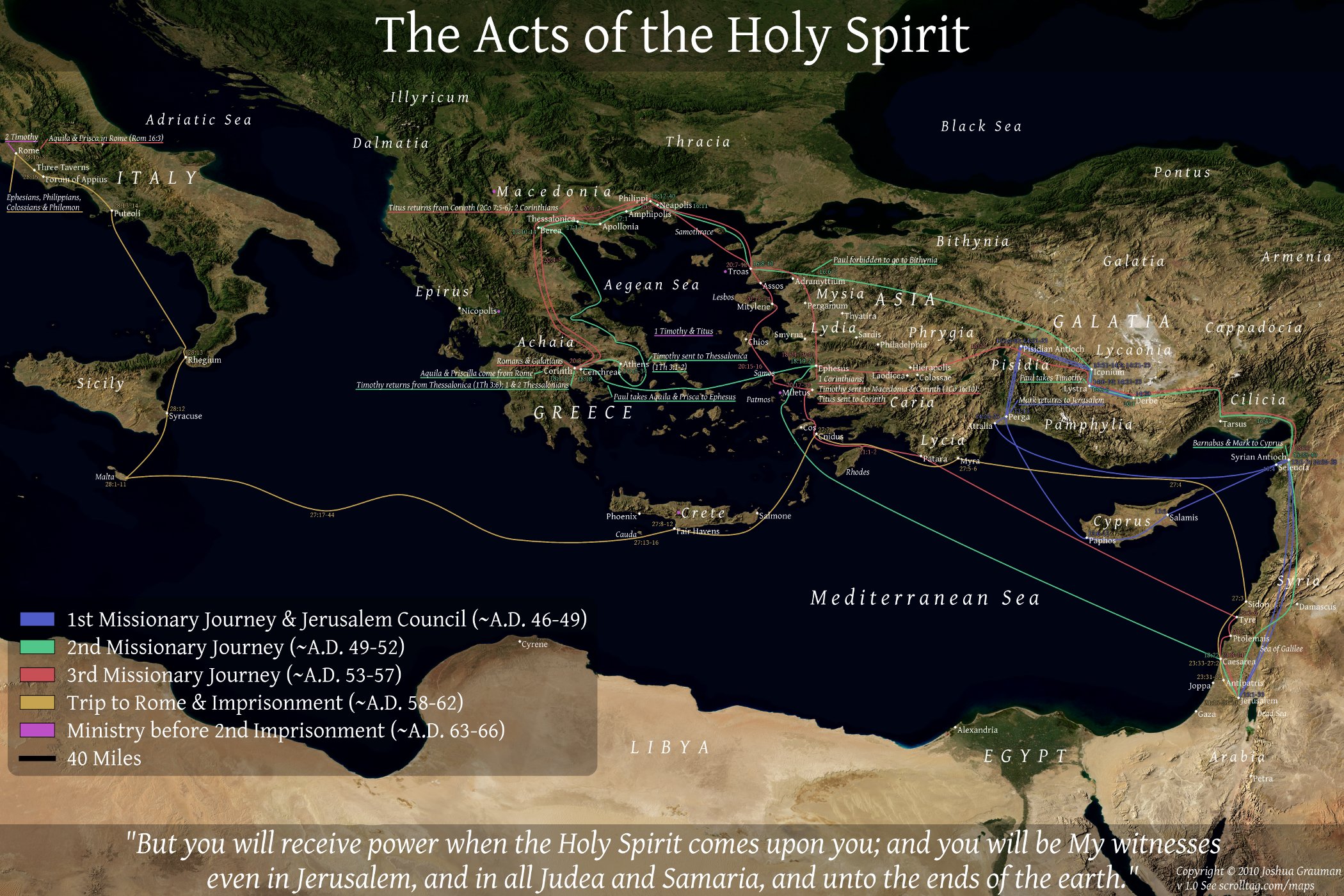
Paul's Missionary Journeys
The Satellite Map of Paul's Missionary Journeys includes important locations, topography and the journeys of the Apostle Paul, along with significant events and references from the book of Acts.
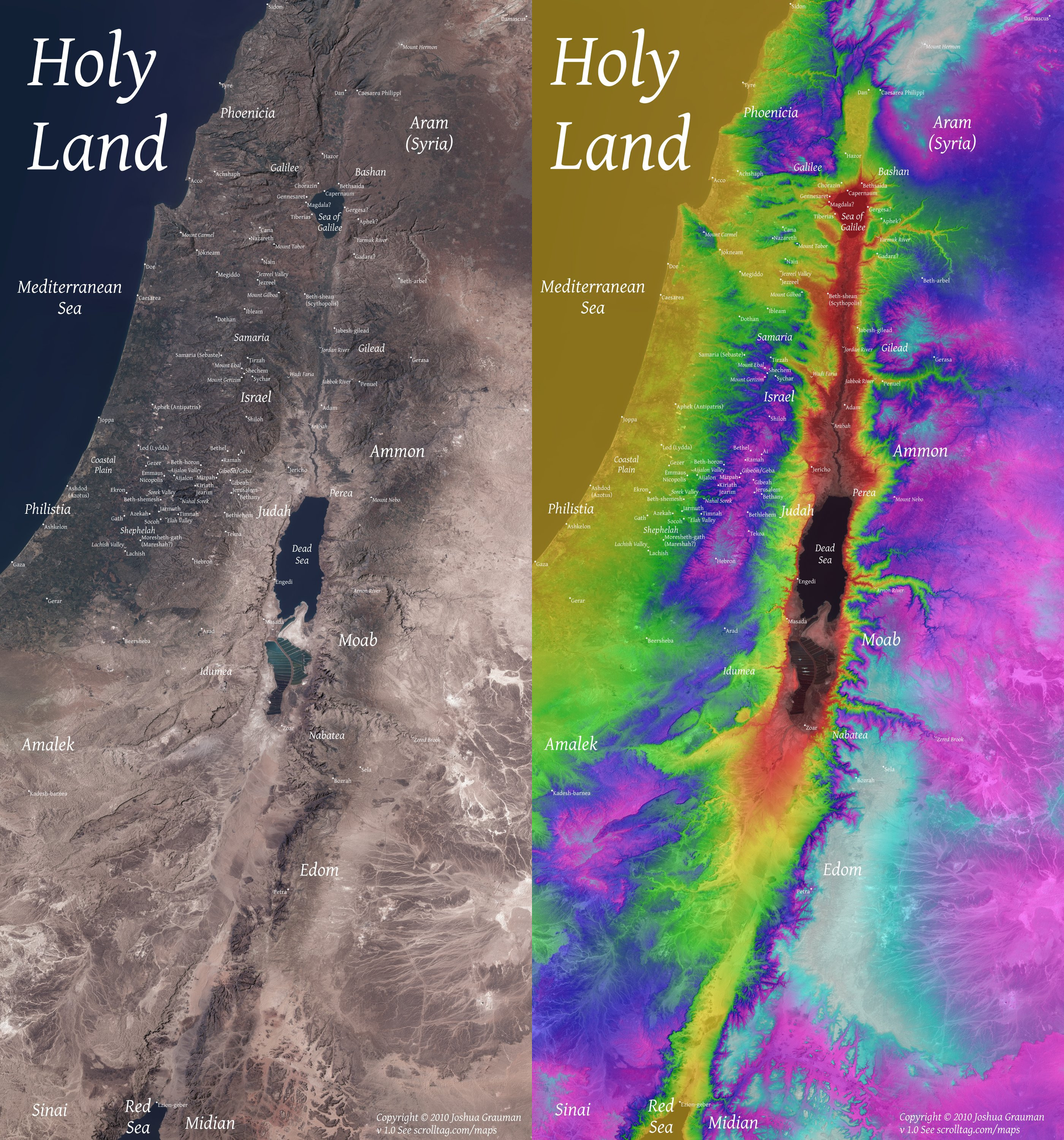
Holy Land Satellite Maps
The Satellite Maps of the Holy Land are satellite maps of Israel overlaid with important New and Old Testament locations, and topography.
Information about the Maps
ScrollTag includes three high-resolution (3000x2000 and 2800x6000) satellite maps of important Biblical places to aid in your study of Scripture. Slighly lower resolution (2100x1400 and 1400x3000) versions of these maps are offered here free for non-commercial use, providing that credit is given to the original author and the map is not altered in any way. Feel free to use them in the classroom, copy or give them to friends or colleagues, make prints or use them in any way except to use them to make money or to alter them. The official license is linked below. Please contact the author if you would like to use the map in any way other than what has been specified.
You can also purchase the higher resolution (3000x2000 and 2800x6000) maps separately without purchasing the ScrollTag main program. These are not licensed under the free license listed below, but under a standard copyright with all rights reserved (this means you may not copy these freely). By purchasing the higher resolution versions of the maps, you also receive the right to make modifications of the map for personal use. You may still not use the maps for commercial purposes though. See the Order page for details. The original maps are very high quality (6000x4000 and 7000x15000). Email if you would like a printed copy.
Click on the maps below to see them enlarged. You can save the image to your home computer by clicking on one of the maps, and once the popup comes up to right click it with your mouse and select 'Save Image as'.
Copyright and Source Information

Satellite Maps of the Bible 1.0 by Joshua Grauman are licensed under:
Creative Commons Attribution-NonCommercial-NoDerivs 3.0 United States License.
Permissions beyond the scope of this license may be available at scrolltag.com/maps.html.
All of the source map material for the high resolution maps originated with NASA. Three different datasets were utilized to make these maps.
The first was the topographical information from ASTER GDEM (http://www.gdem.aster.ersdac.or.jp). Copyright (c) 2009 Earth Remote Sensing Data Analysis Center (ERSDAC) All rights reserved. These maps meet their reversibility criteria for redistribution.
The second was the True Color LandSat Images made available from the LandSat ETM+ dataset and additionally processed by The Geo-Archaeological Information Applications (GAIA) Lab at the Archaeological Research Institute, in the School of Human Evolution & Culture Change at Arizona State University (http://gaialab.asu.edu/home).
Lastly was the satellite images which are part of Blue Marble Next Generation: Blue Marble: Next Generation was produced by Reto Stöckli, NASA Earth Observatory (NASA Goddard Space Flight Center). See The Blue Marble Next Generation—A true color Earth dataset including seasonal dynamics from MODIS (880 kB PDF) for acknowledgments. Anyone using or republishing Blue Marble: Next Generation please credit “NASA’s Earth Observatory” (See http://earthobservatory.nasa.gov/Features/BlueMarble/bmng.pdf).